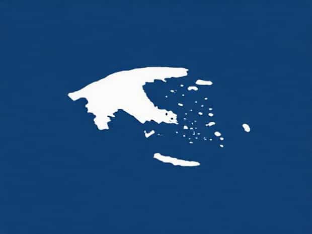
Map Of Cyclades Islands Greece
The Cyclades Islands are a group of picturesque islands located in the Aegean Sea, southeast of mainland Greece. Known for their whitewashed buildings, blue-domed churches, and stunning landscapes, the Cyclades are among the most iconic and frequently visited destinations in Greece. A map of the Cyclades Islands reveals a rich geography of volcanic and non-volcanic islands, each with its own distinct culture, history, and natural beauty. Understanding the layout of the islands helps travelers navigate between popular destinations like Santorini, Mykonos, and Naxos, as well as discover lesser-known gems that offer tranquility and authentic Greek experiences.
Geographical Overview of the Cyclades Islands
The Cyclades form a circular archipelago in the central part of the Aegean Sea, which is how they received their name, derived from the Greek word kyklos,” meaning circle. This group consists of about 220 islands and islets, though only around 24 are inhabited. The islands are spread over a considerable area, creating a complex network of waterways and maritime routes that are well illustrated on detailed maps. Their location makes them accessible from the Greek mainland by ferry or short flights, with the largest and most visited islands being focal points for tourism.
Main Islands and Highlights
Maps of the Cyclades often highlight several key islands that attract millions of visitors each year. These include
- SantoriniFamous for its volcanic caldera, dramatic cliffs, and breathtaking sunsets in towns like Oia and Fira.
- MykonosKnown for its vibrant nightlife, beautiful beaches, and traditional windmills that dot the landscape.
- NaxosThe largest Cycladic island, offering fertile lands, historic ruins, and long sandy beaches suitable for family vacations.
- ParosPopular for its charming villages, marble quarries, and water sports such as windsurfing and kitesurfing.
- IosKnown for its youthful energy, nightlife, and historical sites including ancient ruins and medieval churches.
Understanding the Cyclades on a Map
A map of the Cyclades Islands provides crucial information for travelers, helping them visualize distances between islands, ferry routes, and points of interest. The islands are organized in clusters, with some positioned closer to the mainland, like Kea and Kythnos, and others further into the Aegean Sea, such as Santorini and Anafi. Maps also show topography, highlighting mountainous regions, valleys, beaches, and volcanic formations, allowing tourists and researchers to better understand the physical geography of this unique archipelago.
Transportation and Connectivity
Transportation between the Cyclades Islands is a key consideration for travelers. Ferries and high-speed catamarans are the primary mode of inter-island travel, with routes connecting major hubs like Mykonos, Santorini, and Naxos. Smaller islands may have limited ferry services, and local boats often provide access to secluded beaches or nearby islets. Maps that include ferry routes, ports, and travel times are invaluable for planning multi-island itineraries, ensuring efficient and safe navigation through the Aegean waters.
Historical and Cultural Significance
The Cyclades Islands are rich in history, dating back to the Bronze Age Cycladic civilization. Archaeological sites, such as the ancient ruins on Delos and Naxos, are clearly marked on maps and attract historians and tourists alike. Each island has a unique cultural identity, reflected in architecture, cuisine, festivals, and local traditions. Understanding the geographical layout of the islands helps visitors contextualize the spread of ancient settlements, maritime trade routes, and cultural exchanges that shaped the region over thousands of years.
Natural Attractions and Outdoor Activities
The Cyclades offer diverse outdoor experiences, from hiking trails on volcanic islands to sailing and snorkeling in the clear Aegean waters. Maps highlight areas such as Santorini’s volcanic caldera, the sandy beaches of Naxos, or the windsurfing hotspots on Paros. Tourists often use maps to locate hiking paths, coastal cliffs, and protected natural reserves. The islands’ terrain varies from rocky and mountainous to flat and fertile, providing options for both adventure enthusiasts and those seeking leisurely exploration.
Tourism and Local Economy
Tourism is the backbone of the Cyclades economy, with maps of the islands often emphasizing popular resorts, beaches, restaurants, and cultural landmarks. Seasonal influxes of visitors impact ferry schedules, accommodation availability, and local markets. Detailed maps can assist travelers in discovering lesser-known villages that retain traditional charm, contributing to sustainable tourism and support for local economies. From bustling Mykonos nightlife to the serene landscapes of Anafi, maps help balance tourist exploration between crowded and tranquil areas.
Flora, Fauna, and Environmental Conservation
The Cyclades islands are home to unique ecosystems, including endemic plants and protected marine areas. Maps showing natural reserves, hiking trails, and bird-watching spots encourage responsible tourism and environmental awareness. Islands such as Amorgos and Serifos are known for their biodiversity, while conservation programs aim to protect fragile habitats from overdevelopment. Visitors who refer to environmental maps gain insights into safe areas for wildlife observation and eco-friendly travel practices.
Local Culture and Lifestyle
The Cyclades are not only geographically fascinating but also culturally rich. Traditional Cycladic architecture, including whitewashed houses, narrow streets, and blue-domed churches, is clearly marked on many maps to highlight towns of interest. Local markets, artisan shops, and regional culinary specialties, such as fresh seafood and cheeses, are spread across the islands. Maps help tourists plan visits to cultural festivals, historical sites, and craft workshops, allowing them to engage authentically with island communities.
Practical Tips for Using a Map of the Cyclades
When planning a trip to the Cyclades Islands, maps provide more than just navigation. They offer insights into ferry connections, hiking trails, beaches, and historical landmarks. Tips for effective use include
- Marking main ports and ferry schedules to plan island-hopping itineraries.
- Identifying hiking trails, beaches, and scenic viewpoints for outdoor activities.
- Highlighting towns and villages for cultural and culinary exploration.
- Noting protected natural reserves to ensure responsible travel and conservation.
- Understanding topography to prepare for mountainous or volcanic terrain.
A map of the Cyclades Islands in Greece is an essential tool for travelers, historians, and nature enthusiasts. It illustrates the unique geography, transportation networks, cultural sites, and natural beauty of the archipelago. From popular islands like Santorini and Mykonos to quieter destinations like Anafi and Sikinos, understanding the layout enhances planning and enriches the experience of visiting these iconic Greek islands. The Cyclades offer a combination of breathtaking landscapes, rich history, and vibrant local culture, making them a must-visit destination for anyone exploring the Aegean Sea.